Pryguny and Molokane in Utah — 1914-1918
 By
Andrei Conovaloff. Updated 19 April 2017
By
Andrei Conovaloff. Updated 19 April 2017In 1914, about 100 Spiritual Christians from Russia fled from Los Angeles to a remote and dry area in north west Utah, in west Box Elder County. Most were Pryguny (Jumpers) mixed with a few other Spiritual Christian faiths from Russia. Not all were ethnic Russians.
They said they were persecuted in by the US government which required marriage licenses, parents not to arrange marriages, and kids to attend school. They also wanted to isolate their lifestyle from the modern urban environment. Women must wear long dresses and head shawls.
They tried to buy and farm about 10 square miles distributed over a large area and built a small village about 7 miles south of the small town of Park Valley, 15 miles northwest of the shore of Great Salt Lake.
They wanted to establish an isolated religious Russian language and culture farming colony and were attracted by a brochure promising: "Invest Dimes and Reap Dollars ..." They invested dollars and reaped pennies. Swindled, their utopian ideology was extinguished, and all moved back to California within 4 years.
"On an attempt of the
peasants to settle in Utah, twenty families contracted to
buy farms at $100 per acre, 130 acres to a family. One
fourth of the crops were to be paid to the company, which
promised to provide water; but the company failed to find
water and all the settlers and the company itself went to
pieces. The settlers' losses were very heavy, some losing
$1,000, some $2,000. They were again compelled to return
to Los Angeles." (Speek, 1921)
Only a few migrating native Americans ever lived there before. No one lives there now. Apparently no one has since been able to successfully farm their abandoned land. About 1917 a former resident working in California complained to the U.S. government:
"I do not dream of buying a
farm any more. I have tried it twice." The first time he
was swindled out of his money with a forged document. The
second time, a seemingly official 'Russian American agent'
in Salt Lake City who showed fine specimens of fruit and
vegetables, and 'photographs of good cattle and splendid
fields,' offered this land at $25 an acre. So he with
other Russians sold their houses and bought the property.
"When we arrived we found a waterless desert. Several returned immediately seeing their mistake but about thirty families remained, tilling the soil and suffering hunger. Soon they saw what they had planted did not grow, and were obliged to leave everything and go to the nearest cities in order to earn money. That is what happens to the Russian people in America." (Davis, 1922)
"When we arrived we found a waterless desert. Several returned immediately seeing their mistake but about thirty families remained, tilling the soil and suffering hunger. Soon they saw what they had planted did not grow, and were obliged to leave everything and go to the nearest cities in order to earn money. That is what happens to the Russian people in America." (Davis, 1922)
These mixed faiths of Spiritual Christians from Russia separated into 2 groups, the largest of varieties of Pryguny tried to form a village, and got a school house. A few varieties of Molokane lived nearby to the north.
East of the village, a small 2-grave fenced cemetery with Russian-language headstones is the most visible reminder that people from Russian were there. The US GeoSurvey named a topographical quad map after Russian Knoll, the only landmark in the area. Few items remain among the eroded foundations of the village houses and school.
|
 |
Scholarly Articles, chronological
- Speek, Peter Alexander. Russian
Sectarian
Peasants in the West, A Stake in the Land, 1921. Pages 24-33. —
In 1918, Dr. Speek as Director of the Slavic Section,
Library of Congress, met and surveyed immigrant Russian
sectarians in Los Angeles and San Francisco to report on
rural development, for the 11-volume Study of Methods of
Americanization.
- Davis, Jerome. The Russian immigrant. New York : Macmillan, 1922. Page 53
- Bowen, Marshall E. “Promoters and Pioneers: A Perspective on the Settlement Process in the Utah-Nevada Borderlands.” Pioneer America Society Transactions 15 (1992): 23-31.
- Bowen, Marshall E. Utah
people
in the Nevada Desert : Homestead
and Community on a Twentieth-century Farmers' Frontier.
Utah State University Press, Logan UT. 1994. — Chapter
One: The Framework, pages 1-6.
- Dorothy K. Morris, LeGrand Morris, and Rod Morris. "Park Valley History" Preliminary Draft. The Box Elder County Centennial History Project, 1996.
- Bowen, Marshall E. “Part-Time Pioneers.” Pioneer America Society Transactions 20 (1997): 1-12.
- Huchel, Fredrick M. Non-LDS-churches in Box Elder County: The Molokan Russian Settlement. A History of Box Elder County, Utah Centennial County History Series. 1999. Pages 176-178.
- Bowen, Marshall E. "Crops,
Critters, and Calamity: The Failure of Dry Farming in
Utah's Escalante Desert, 1913-1918," Agricultural History,
Vol. 73, No. 1 (Winter, 1999), pp. 1-26.
- Sarah Yates. "From Dust to Dust: A Russian Sojourn." Beehive History, Volume 25 (1999) pp 14-17. 4 photos. This paper was presented April 20, 2000, during the noon "Utah History Brown Bag Series" by the Utah State Historical Society, Utah State Archives, Salt Lake City, Utah.
- Bowen, Marshall E. "Russian Colonists in the Utah Desert: [Prygun and] Molokan Community in Utah — 1914 to 1918". A paper presented April 10, 2003, at the Association for Arid Lands Studies, Western Social Science Association Conference, Las Vegas, Nevada
- Bowen, Marshall E. "A Russian [Prygun and] Molokan Farmers' Village in Northwestern Utah.." Presented at 67th Annual Meeting, Association of Pacific Coast Geographers. September 8-11, 2004. Cal Poly State University, San Luis Obispo, California. Paper Session II-C Historical Geography and Evolving Cultural Landscapes — Friday, 10:15-12:00 — Business, Room 111 — 10:15 am
- Bowen, Marshall E. "Russian Molokan Villages in Arizona." Paper presented at the 2005 Annual Meeting of the Association of Pacific Coast Geographers, Phoenix, Arizona. October 19-22, 2005, Arizona State University Downtown Center. — Russian sectarian Pryguny and Dukh-i-zhniki.
- Bowen, Marshall E. "Two Russian Sectarian Molokan Agricultural Villages in the Intermountain West" (PDF 691K), Association of Pacific Coast Geographers, APCG Yearbook, Volume 68, 2006. — Russian sectarian Pryguny and Molokane in Utah and Arizona.
- Morris, Lesley R. "Park
Valley, Utah Project Area History." October 6, 2008. — Short
history with photos and map from 1911 pamphlet promoting
the Pacific Land and Water Company.
- "Russian
Molokans in Utah: A Conversation with Marshall Bowen,"
Utah Historical Quarterly, Summer 2015
(vol. 83, no. 3). — Map of village.
- "Minister
Fights
Against Force In Work Of Relief; Rev. D.W. Bartlett,
Former Salt Lake Pastor, Opposes Prison and Punishment
in Uplifting the Unfortunate—Tells of Social
Settlement Work Among the Foreigners." Salt Lake Herald,
December 31, 1908,
page 10. — Resident of Salt Lake City 20 years, moved to
LA 1903. "It is the ultimate purpose to establish these
peasants on farms."
- "Colony
of Russians Coming to Utah," The Box Elder News,
February 4, 1914,
page 3. — For religious freedom from modernism in
women's dress, delayed marriage, and American laws to
register marriages.
- "Colony Of Russians To Settle In Park Valley," The Ogden Standard, 1914 April 7, page 5.
- "Russians Are To Go Through Ogden Tonight," The Ogden Standard, April 8, 1914, page 6.
- "Russians Come to Utah for Freedom," The Box Elder News. Thursday, April 9, 1914, page 7.
- "Russian
Colony Arrives," The Ogden Standard, April 10, 1914, page 10 — 5
coaches, 186 people on 16,000 acres.
- "School
Site for Russian Colony," The Box Elder News,
April 15, 1914,
page 3.
- "Box Elder County News: School for Russians," The Ogden Standard, October 17, 1914, page 10.
- "Box Elder County News: New School In Boxelder," The Ogden Standard, January 2, 1915, page 5.
- "Jewish Colony In Utah Distressed," The Ogden Standard, February 4, 1915, page 8. — Similar Jewish colony in trouble.
- "Southern California Is Offensive," The Ogden Standard, April 25, 1915, page 4.
- "Russian Colony In Boxelder Near Starvation," The Ogden Standard, August 6, 1915, page 7.
- "State Sells Land in Sanpete County," The Ogden Standard, January 20, 1916, page 6. — Similar Jewish colony sold.
- "Random
References: Russians Hopeful," The Ogden Standard,
November 28, 1916, page 7.
- "President [presbyter] of Russian Colony Accidentally Kills His Wife." The Box Elder News. May 7, 1914.
- "Park Valley is Wheat Country: Russians Develop Rich Farms Where Sagebrush Was Growing Year Ago," Salt Lake Herald, May 23, 1915, page 32.
- "Defy
Arid Wastes; Wonderful Work Of Russians In Central
Asia; All the Military Power of the Czar Would Have
Been of No Avail but for the Patient Labor of the
Colonists," The
Logan Republican, December 28, 1916, page 8. —
How Russians colonize new villages.
- "By
Box
Elder
Sheriff:
Remains
of
Russ
Colony
Stirs
Preservation Work." Deseret News and Telegram, Salt Lake
City, Utah, page 31, September 17, 1959. — Photo:
"Russian Underground—This cellar, best preserved of the
many at Russian Colony, may have doubled as living
quarters during cold winters."
- "Grave site is the only reminder of Russian pioneers' brief stay", Associated Press, Utah. July 19, 1999.
- "Brigham City Branch Report", The American Association of University Women. AAUW of Utah, The Sego Lily, Volume 66, Issue 3, Spring 2009, Page 2.
- "Park Valley is resting place of two Russian immigrants", by Di Lewis, Standard-Examiner, Ogden, Utah. September 20, 2009.
- "Invest Dimes and Reap Dollares in Park Valley Utah", Pacific Lane & Water Company Ad, page 1. , J. Willard Marriott Library, University of Utah (Identifier 39222001665442.tif, Photo No. 3900, DDN 659.1)
- Russian Settlement Cemetery, Utah History Cemetery Database, Box Elder County. Size 108 sq.ft.
- Russian
Settlement Cemetery, Find-A-Grave, 2007
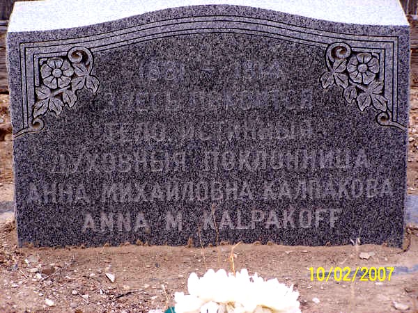
- Anna
M. Kalpakoff (1881-1914)
- Mary Mathew Kalpakoff (1887-1915)
-
John W. Van Cott. Utah Place Names: a comprehensive guide to the origins of geographic names. 1990. Page 324.
- Correspondence with Dr Bowen
- Pryguny and Molokane in Utah, 1914-1918
- Box Elder County Tourism - Kids Page
- USGS Russian Knoll Quad, Utah, Topographic Map — Q0508
- Russian
Settlement,
Utah. Wikipedia.com
 Utah
Place Names
Utah
Place Names
RUSSIAN KNOLL (Box
Elder) is ten miles
[7 miles straight]
south of Park Valley* near the ghost town site of the former
Russian Settlement,T12N, R13W, SLM; 4,941' (1,506 m), 516.
RUSSIAN SETTLEMENT* (Box Elder) is a ghost town site ten miles south of Park Valley*. It was established in 1914 by a small group of Russian migrants. After about six year the settlement failed and there is nothing left of the site except a small cemetery, one-half mile east of Russian Knoll.
T12N,R13W,SLM; 4,850' (1,478m), 516, 546.
RUSSIAN SETTLEMENT CEMETERY is absent in this listing.
John W. Van Cott. Utah Place Names: a comprehensive guide to the origins of geographic names. (Utah Press, 1990) Page 324.
USGS Russian Knoll Quad, Utah, Topographic Map — Q0508
Map section showing surface features Russian Knoll and cemetery Graves.Approximate location of village and school added.

Click on map above, then "Topo" at right to see this map.
Search for "Russian Knoll", Search Type: "USGS Map Name" on the U.S. Geological Survey: Map Locator website
Funeral of Mary Kalpakoff, February 1915, and original gravemarker
Box Elder County
Utah, USA
This cemetery and hill (knoll) are two of only a few place names in the US attributed to
Jumpers or Molokans. See Russian Knoll in the background above the fence.
 |
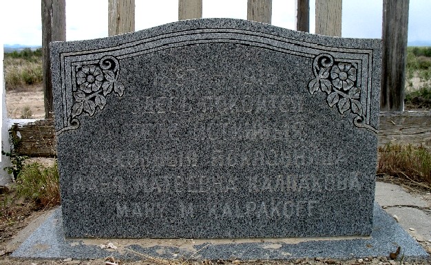 |
| Anna Mathew Kalpakoff (1881- May 7, 1914) | Mary
Mathew Kalpakoff (1887-1915) |
Grave site is the only reminder of Russian pioneers' brief stay — 07/19/99 Park Valley
Utah (AP) [...]. According to an article reprinted from the Strevell Times on May 7, 1914, in the Box Elder News, Andrew Kalpakoff had just emptied the magazine of his .22 rifle when his wife said she was afraid of the weapon. "Mr. Kalpakoff raised the gun to show her it was empty and with it pointed towards her pulled the trigger, only to find that there remained a cartridge in the barrel. The bullet entered his wife's heart. She fell to the floor and in 10 minutes was dead." Anna Kalpakoff was buried in the Park City Cemetery. Her husband was so grief-stricken he had to be restrained so he wouldn't kill himself. When Anna's sister-in-law, Mary Mathew Kalpakoff, died in childbirth a year later, Anna's remains were moved next to Mary's.
Created by: mbush_utah — Record added: Jan 2, 2007 — Find A Grave Memorial# 17257995
Park Valley is resting place of two Russian immigrants
By Di Lewis, Standard-Examiner, Ogden, Utah — Sep 20 2009PARK VALLEY — Out in the desert, a few miles south of Park Valley, a white picket fence rises from the sagebrush.
Only the very observant or those who know it's there will see it. That weather-beaten fence enclosing two headstones inscribed in Russian is one of the few remnants of a short-lived Russian colony, founded in 1914 in the Box Elder desert.
The road isn't well-traveled and visitors are often left getting pulled out of the mud by a Park Valley resident.
But on dry, clear days, those with a sense of adventure can travel the dusty roads to a long-forgotten village.
One of those adventurers was Marshall Bowen, a retired geography professor from the University of Mary Washington, in Fredricksburg, Va., who heard about the place when he was doing research at Utah State University.
More than 25 years later, Bowen is one of the few people to study the tiny village of Russians who decided to make the Utah desert their home, but left a couple years after they arrived, unable to live in the harsh climate.
Two closely related religious groups made their homes in Utah, the Molokans and Jumpers. The groups left Russia's Caucasus region in the early 1900s when the government military service exemption expired and some of the pacifistic Christian religions chose to move rather than fight.
"It's really a story of what happened to this family and what happened to that family and seeing if you can make some sort of pattern out of it," said Andrei Conovaloff, a [Prygun] Jumper currently living in Arizona who maintains a Web site about Molokans and Jumpers, www.molokane.org
Thousands made their way to California, with the Molokans staying mostly in San Francisco and Jumpers in Los Angeles.
"They settled in the city because that's where there were job opportunities, and they had to survive. It was a chain migration," Bowen said. "They really were a peasant group, and the elders really didn't think the city was the right place for them. There was too much worldliness and too much opportunity for their children to observe worldliness."
The leaders pushed the congregations to live a godly life and felt it would be easier in an isolated rural area.
So when an advertisement from the Pacific Land and Water Company promised rich land and good weather for $17.50 an acre, about 20 families, 100 people in all, left California for four square miles in Utah, becoming one of several groups setting out to re-create their rural Russian life in remote parts of the [western] U.S.
"This is one of a dozen attempts that failed, but the fact that they stayed there for a couple of years shows they tried hard, said Conovaloff.
The 20 Jumper families made their own settlement near what is now called Russian Knoll. A few miles north, four Molokan families had their own group.
The people were duped, said Conovaloff. He said their land was dry and getting enough water to live on was nearly impossible.
Finding out their new home was not all that was promised did not stop them from building a village like they had in Russia. Long, thin plots lined a central street. The houses were close to the street, the school was on the west end of the street and the cemetery on the east, Bowen said.
Tragedy struck a month after arriving, when Anna Kalpakoff was accidentally shot by her husband, Andrew.
"Andrew was cleaning a gun and Anna said, 'Andrew, you shouldn't clean that in the house.' He said, 'Look, it's not loaded.' But it was," Bowen said, noting that Andrew Kalpakoff later considered suicide.
Anna was first buried in an LDS graveyard in Park Valley, Bowen said, but when her sister-in-law, Mary Kalpakoff, died less than a year later during childbirth, Mary and Anna were buried together in a new cemetery near in the village.
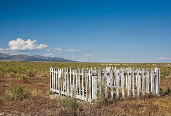
A small, two-headstone graveyard sits alone on the plains near the town of Park Valley.
NICHOLAS DRANEY/Standard-Examiner
Faded silk flowers sit at both graves, which had the current headstones placed by Mary's grandson, Ed Kalpakoff, in 1966, Bowen said.
Although there were good things, many births and a county school in 1915, life was just too hard, and repeated crop failure forced them out.
The Jumpers completely abandoned Utah by 1917, Bowen said.
"They were disillusioned," he said. "They were glad to get out of there. ... They felt the land company had duped them. I think they turned their back and I don't think they looked back on it."
Bowen did find one woman, now dead, who was a very young girl when her family lived near Park Valley.
Anna Potapoff Reibin was part of the smaller Molokan group [Molokan faith], and she told Bowen they would occasionally go watch the Jumpers leaping around in religious ecstasy.
The two groups rarely socialized. Conovaloff compares them to FLDS [Fundamental Church of Jesus Christ of Latter Day Saints] and LDS [Church of Jesus Christ of Latter Day Saints]. "Neither group wants to admit they have something to do with the other, and everyone on the outside calls them Mormons," he said.
But Bowen said Reibin brought the community to life. "She provided a lot of warmth and empathy for the Molokan faith and Molokan people and the effort they went through to do what they did, unsuccessful though they might have been."
Though some may remember the time through old stories of Park Valley, the only witness now to the hopes and failures of 100 people are a few empty cellars and two lonely headstones.
Brigham City Branch Report
The American Association of University Women. AAUW of Utah,The Sego Lily, Spring 2009, Volume 66, Issue 3, Page 2.
January branch meeting featured the story of the Russian Colony in Box Elder County. A group of Russian immigrants traveled to the Park Valley area in 1914, to form a utopian agricultural colony, but drought and harsh conditions battered their dreams and the colony was disbanded in 1918. Today, two graves enclosed within a worn picket fence are the only reminder of the group’s existence there.
Their story, along with photos provided by descendants of some of settlers, was told by Sarah Yates. Based on scant information, Yates began researching the colony with the idea of writing a feature story. Contacts, particularly the grandson of one of the women buried there, provided poignant stories. Yates’ articles were published in the News Journal and with the Utah State Historical Society, and additional studies based on her research continue.
Research by Dr. Marshall E. Bowen
 Dr.
Marshal
E. Bowen is professor emeritus (retired) of cultural
geography and an expert on isolated agricultural communities
formed in the early 1900s. He has been actively researching
Pryguny
and Molokane since
2000 — collecting family interviews, geographical analysis,
historic land documents, site survey, photos, collaborating
with local historians, etc.
Dr.
Marshal
E. Bowen is professor emeritus (retired) of cultural
geography and an expert on isolated agricultural communities
formed in the early 1900s. He has been actively researching
Pryguny
and Molokane since
2000 — collecting family interviews, geographical analysis,
historic land documents, site survey, photos, collaborating
with local historians, etc. Bowen first learned about a Russian settlement near Park Valley, Utah in 1980 while doing research at Utah State University while he was comparing and contrasting 2 communities (Mormon, and non-Mormon mostly German) that migrated from Utah to northeast Nevada, near Wells, from 1909 to 1915, which resulted in a two papers and a book. His knowledge of geography enhanced his analysis of social, economic, and agricultural factors which resulted in a spacial-geographic presentation explaining the relative success of the Mormon resettlement.
- "Turnover of Pioneers and Property in a Marginal Nevada Farming Community", Yearbook of the Association of Pacific Coast Geographers, Volume 42, 1980
- "A Backward Step: From Irrigation to Dry Farming in the Nevada Desert," Agricultural History 63 (1989): 231-242.
- Utah People in the Nevada Desert: Homestead and Community on a Twentieth-Century Farmers' Frontier (Logan: Utah State University Press, 1994) 134 pages. Chapter One: The Framework, pages 1-6
Bowen produced 4 papers about Pryguny and Molokane in Utah, in 2003, 2004, 2005 and 2006 including Arizona. He submitted the complete text of his 2003 and 2006 papers for publication here.
He presented his first paper in April 2003 at a geography conference in Nevada (below), and graciously sent in that text and and a few photos for posting. In Septemeber 2004 he updated this paper for a geography conference in California.
When Dr. Bowen started his work, sattelite images were not available on the Internet and are added to enhance his papers here. Links are being added as digital files appear online. He did not submit all his photos for posting.
If you can add to his research, please contact Dr. Bowen or this website.
2003
Russian
Colonists in the Utah Desert: Molokan Community in Utah —
1914 to 1918A paper presented April 10, 2003, at the Association for Arid Lands Studies, Western Social Science Association Conference, Las Vegas, Nevada. Photos and maps showing the land Jumpers and Molokans tried to buy.
2004
A Russian Molokan Farmers' Village in Northwestern Utahby Marshall E. Bowen, Mary Washington College
Schedule of Events — 67th Annual Meeting — Association of Pacific Coast Geographers
September 8-11, 2004 — Cal Poly State University — San Luis Obispo, California
(302 KB Word DOC) (Page 5)
Paper Session II-C Historical Geography and Evolving Cultural
Landscapes — Friday, 10:15-12:00 — Business, Room 111 — 10:15 am
(Page 15) Abstract:
Most agricultural villages in the Intermountain West are classic Mormon settlements, laid out in the form of a grid, surrounded by cultivated land and pastures. Elongated farming villages, with houses and lots oriented to a single street, are much more common in lands settled by Mennonites. Few would expect to find a street village resembling those of the Mennonites in Utah. But in 1914 Russian Molokans [and Jumpers] laid out a traditional street village in Park Valley, near the northwestern corner of the state, and lived here for periods of one to four years. Unfortunately, crop failures thwarted their plans, and today the village lies completely abandoned and almost forgotten, a symbol of this distinctive group's attempt to recreate a familiar pattern of settlement in an unforgiving land.
2005
Russian Molokan Villages in ArizonaThe 2005 Annual Meeting of the Association of Pacific Coast Geographers will be held in Phoenix, Arizona — October 19-22, 2005, at the Arizona State University Downtown Center. Dr. Bowen plans to present his new research paper: "A Russian Molokan Farmers' Village in Glendale, Arizona", about the first Arizona Jumper colony. The Arizona congregation will be helping him with content and accuracy. If anyone has suggestions or information to offer, please contact Marshall E. Bowen.
2006
Two Russian Molokan Agricultural Villages in the Intermountain West (PDF)Yearbook of the Association of Pacific Coast Geographers - Volume 68, 2006, pp. 53-78 (University of Hawai'i Press). E-ISSN: 1551-3211, Print ISSN: 0066-9628, DOI: 10.1353/pcg.2006.0006
Abstrract
Agricultural villages established in the second decade of the 20th century by Russian Molokans in Glendale, Arizona, and Park Valley, Utah, bore striking similarities, with long, narrow house lots, dwellings aligned along a single village street, and outlying lands allocated for crop production. With the passage of time, the Glendale village lost much of its Russian flavor as families responded to individual opportunities, personal tragedies, and economic disaster by moving away. In contrast, the Park Valley village was struck down by drought and crop failure. Today, the Glendale village is inhabited entirely by non-Molokans, and is on the verge of being consumed by suburban sprawl, while the Park Valley village, abandoned almost 90 years ago, lies nearly hidden in a vast expanse of rangeland. But at each site it is still possible to find traces of a traditional Old World settlement pattern that was unable to survive in the face of new cultural, economic, and physical conditions that the villages' immigrant residents encountered in the American West.
Grave site is the only reminder of Russian pioneers' brief stay
Associated Press, July, 19, 1999. Archived in: "Got CALICHE?" Newsletter: Archaeology, Anthropology, and History of the Greater Southwest! Southwestern Archaeology (SWA), Phoenix AZ.Utah (AP) — The Russian immigrants who came to a remote Box Elder County site in the early part of this century left almost as quickly as wind whips through sagebrush. But they left their mark — shards of glass, weather-beaten wood boards, a cemetery with two headstones and a white picket fence.
It was in 1914 that the nearly 100 Russians descended on an obscure plot of land south of Park Valley. They were lured by a brochure published by the Pacific Land and Water Co. "Hundreds of acres of land lying ready to respond most generously to the touch of the husbandman," the brochure read. That is not what they found. And by 1917, after sinking their lives' savings into the land, the Russian pioneers abandoned their dreams.
A few descendants of the colonists, and one journalist-historian, are now trying to piece together the struggles of their nameless town. A splotchy history is the result so far.
The immigrants were seeking religious freedom, said Sarah Yates, a longtime writer for the Box Elder News Journal who is now retired. She became interested in the Russians' plight in 1977. "They were coming to set up a utopia-type colony. They could be free of American customs here.
It paralleled the Mormon journey," she said. They were "[Pryguny and] Molokans," who broke away from the Russian Orthodox Church and were persecuted because of their actions. They fled the Republic of Georgia and settled in Los Angeles between 1904 and 1912. But they felt oppressed and out of place.
The brochure must have sounded like a dream. So they packed up all their belongings and took a passenger train to a new home in remote Park Valley. There they built wooden plank houses and dug wells and root cellars. They cleared land for planting and waited for the water to flow. It never did.
George Morzov's grandparents were part of the colony. He and his wife visited the area just last month to see what it was like. "I was very disappointed in the environment," he said. "They were sold a bad deal. Somebody found a group of Russians who were gullible." The colonists walked over seven miles to Park Valley for water and supplies.
Conservative dress standards clothed the women in long black dresses, the men with and shawls. "Can you imagine?" asked chief deputy Lynn Yeates while on a tour of the area. "It must have taken a day to walk to town and back."
Sarah Yates said the colony was mostly older folks. But the minutes of a Box Elder School Board meeting mention the colony would have 20 boys and 20 girls who needed schooling.
There were two deaths in the colony, not counting babies. Both of them were in the same family.
According to an article reprinted from the Strevell Times on May 7, 1914, in the Box Elder News, Andrew Kalpakoff had just emptied the magazine of his .22 rifle when his wife said she was afraid of the weapon. "Mr. Kalpakoff raised the gun to show her it was empty and with it pointed towards her pulled the trigger, only to find that there remained a cartridge in the barrel. The bullet entered his wife's heart. She fell to the floor and in 10 minutes was dead."
Anna Kalpakoff was buried in the Park City Cemetery. Her husband was so grief-stricken he had to be restrained so he wouldn't kill himself.
When Anna's sister-in-law, Mary Mathew Kalpakoff, died in childbirth a year later, Anna's remains were moved next to Mary's. It was this site that Paul Kalpakoff sought in 1948. His mother was Mary Kalpakoff, who died when he was only 2 years old.
Paul Kalpakoff's son still remembers the trip. "He was looking for his mother. His dad would tell him the wind will have blown it all away and you'll never see anything," said Edwin Kalpakoff of Fresno, Calif. But, they did find weather-beaten wooden markers and Edwin Kalpakoff said he remembers foundations still perched on the ground.
Edwin Kalpakoff's father didn't want his mother to be forgotten. He came back in 1966 and replaced the disintegrating wooden markers with modern headstones. He had them inscribed just as the wooden ones had been. "Here lies the body of a true (authentic) worshipper" is written in the liturgical language of the Russian Orthodox Church. They painted the wooden fence around the grave sites.
Edwin Kalpakoff has visited since to look after the markers. Morzov doesn't have any markers of his family's stay in Utah. In fact, he didn't even know his mother had lived there until she passed away. "My mother never mentioned word once."
Morzov learned what he knows about his mother's childhood in Utah from Yates and her articles.
Living in California, he has tried to find others who might remember. "Nobody seems to want to say anything, or they don't know anything. They are very private people and don't like to talk about it," he said.
Morzov said that might be because they don't want to talk about their failure. After only a few years, the desert drove the immigrants back to the Los Angeles area. "They were persistent, energetic and very patient. And they only lasted three years," he said. When they left, they left everything _ the house, the dishes, everything _ and just went back to Los Angeles," Kalpakoff said.
Yates said that after the Russians left, Park Valley residents took some of the furniture and lumber from the homes. "It was good lumber. People took stuff down, outbuildings and such. I just know several people had furniture they say had been from the Russians."
Yates said the area's isolation and dry climate are partially responsible for the preservation of the graves. That may change soon as irrigated crops move closer.
Kalpakoff, whose father passed away in 1989, wants to get the little cemetery marked as a state historical site. "My Dad cared about her. He didn't want anything happening to the grave site. Anything to save it from being torn down, that would be my dream." Kalpakoff pauses when asked why he wants to save the site. He tries to speak, but only a whisper comes. Another pause. "Well, it was my Dad. I must be doing it for his sake and my sake, and hopefully everything can be kept safe."
The Russians in Box Elder County History
Park Valley HistoryResearch by Dorothy K. Morris, Historical Context by LeGrand Morris, Typing and Editing by Rod Morris
In Cooperation With The Box Elder County Centennial History Project, 1996. Preliminary Draft
Lafant, or the Russian Village School
OTHER SCHOOLS
... There was also a school established for the Russian Colony. In August 1914 Harold LaFont had asked for a school there, stating that there were 19 families with 40 school age children. A portable school house was ordered, and by February 1915 it was being put on a foundation. In March the Pacific Land and Water Company offered to pay the teacher if the school would be opened at once. In May blackboards were to be installed before the school opened. The teacher was reported to have been one of the colonists. In November 1915 the school board was wondering if the school should be kept open any longer, because the Russians were moving away. Then in August 1916 the stove from it was sent to the Lucin School. In September it was decided to take the Russian School apart and ship it to North Promontory. ...
THE RUSSIANS
A colony of exiled Russians, seeking a “mecca where they could enjoy isolation and peace” came to the area in 1914 and homesteaded in the dry sage brush flats below Park Valley and along the lower part of Dove Creek. The main reason for their migration to this isolated area was so their children could grow up in their own culture and traditions, with out the corruption of the outside world. A.P. Karyakin was their presiding authority.(11)
About 100 of them left the Los Angeles, California area in early April, where they had previously established a colony, to make the journey to Box Elder County, Utah. Another “large contingent” soon followed. In the Park Valley area they had already purchased large tracts of land. There they immediately set out to farm and raise livestock, and declared their intention to build a town of their own on their property. They began the journey to Utah “splendidly equipped” on a special train of four cars, two for baggage and two for passengers. The coaches were outfitted for comfort and were supplied with their own stoves so that the women could cook their own meals on the way, and not have to come in contact with Americans.
The older generation especially strongly objected to their young adopting the American customs, especially in dress. They left California purposely to seek isolation and to be free to follow their own customs they had brought with them from their native land.(17) Among the persecutions they had to endure was a recent court decision rendered in Los Angeles by a Judge Monroe, who held that a young woman named Sarah Katoff [Kotoff] was not legally married to Jacob Ural, who claimed her as his wife, and that the marriage which had been entered into under the Russian colony’s customs, was annulled. This action greatly incensed the older Russians, and they at once began their preparations for fleeing from what the termed the “persecution.” They thus began looking about for a place to go and became aware of the Park Valley area that was currently being touted by the Pacific Land and Water Company as a place with “splendid possibilities.” They became interested and one of their leaders was sent to Utah to make a “thorough investigation” of the conditions in the valley. His report was satisfactory and negotiations were then begun, resulting in the purchase of “several thousand” acres of the land which was boasted of as being very rich. The Russians were reported to be excellent farmers, skilled in several branches of husbandry, and their coming was awaited as a boost to the region. The first of the group was said to have passed through Salt Lake City on about April 10, 1914.(17) Among the Russian colonists was Andrew Kalpokoff [Kalpakoff], said to be the group’s president, and his wife. They had resided for about the ten years previous in Los Angeles, California. During that time Andrew had become well known and was looked upon favorably. For the five years previous he had been engaged in the mercantile business and had met with considerable success. He won the respect of not only the Russians, but all with whom he did business. He labored hard to provide for his family, and with his wife’s assistance, he succeeded well. About March or April of 1914 they moved with the other Russian Colonists to the Park Valley area. Together they looked forward to the time when they could enjoy life on their own farm.
A very sad situation happened about a month after the colonists arrived. Andrew Kalpokoff had just emptied the magazine of his 22 rifle in order to clean it. His wife, who was frightened of weapons, sat at his side. Mr. Kalpokoff raised the gun to show her that it was empty, and pointed it toward her and pulled the trigger, only to find that a cartridge remained in the chamber. The bullet, upon discharging, struck Mrs. Kalpokoff in the heart. She fell to the floor and in ten minutes was dead.(3)
The grief stricken husband lost his mind and it was with considerable difficulty that three men who witnessed the accident prevented him from terminating his own life. When he regained self-control, his grief was almost more than he could endure.(3) His wife was said to be “an extremely good woman, loved dearly by all who knew her. She was generous and always willing to assist those in need. She could be found with the poor and at the bedside of the sick--a true, devoted wife and loving mother, in the prime of life, being but 36 years of age, and in perfect health and spirits.”(3)
The funeral was held Monday, May ??, 1914. “Impressive services” were attended by the entire Russian colony, and a large number of Park Valley residents as well. She was buried in Park Valley.(3)
Some of the names of the colonists, appearing on the tax rolls of the county, include Kolpakoff, Kobzeff, Shegloff, Chernobeaff, Voldareff, Danetrieff, Karyahin, Kunahoff, Volkoff, Shubin, Eleen, Rudsmetkin, Melnikoff, Coepoff, Homenoff, Dofapoff, Slevin, and Tabbot. The name Neff [not Russian] may have also belonged to this group.(18)
In time, however, the crops of the colonists failed. The Pacific Land and Water Company refused to carry the colonists any longer. They were forced to liquidate their holdings. They had traded as well at the Park Valley Store on account. There they attempted to settle their accounts honorably, with the store taking back horses, cattle, wagons, machinery, and various other items, but the store as well was shorted several thousand dollars.(20)
IRRIGATION AND WATER DEVELOPMENT
Perhaps water has played the largest part in shaping the lives and destiny of Park Valley. As the Indians frequented the valley, on their annual migrations, hunting and gathering food, they left behind evidence of their passing, in arrowheads and corn grinding stones, mainly near the natural springs flowing along the foothills. As the first settlers arrived, they also made their homesteads by the springs or along the mountain streams. When the first settlers first arrived, the intermountain west was in a much wetter cycle than normal. The cattlemen and sheep men stocked the range to what the available water and annual rainfall would then allow. Within a few years they found that this was too much, and that the range was being overgrazed. When drier years set in, many families who were not fortunate enough to have settled on more permanent water sources were forces to move away or seek elsewhere for a better livelihood. Many took with them shattered dreams, but left behind their contributions to the history of the valley. Some of their home sites can still be seen, in empty cabins or outlines of forgotten fields in the sagebrush. Many have been entirely forgotten as the cabins were removed or the traces in the sagebrush disappeared. Some, especially like the Russian Settlers who were lured her by false promises, found the area just too dry to dryfarm.
...
BIBLIOGRAPHY
| 3. |
"President [presbyter] of Russian Colony Accidentally Kills His Wife." The Box Elder News. May 7, 1914. |
| 11. |
Our One Hundred Years, 1870-1970. Park Valley Centennial. by Norine K. Carter, Letitia W. Palmer, Dorothy K. Morris |
| 17. |
"Russians Come to Utah for Freedom." The Box Elder News. Thursday, April 9, 1914. |
| 18. |
Tax roll of Box Elder County. (The exact source of this list in unknown. It was probably printed in The Box Elder News). |
| 20. |
Research notes of Dorothy K. Morris, gathered from 1992 to 1996. |
| 42. |
History of Box Elder County. 1937. Compiled by the Box Elder Chapter of the Daughters of the Utah Pioneers |